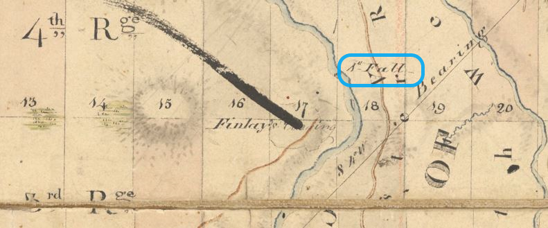
Identified as the 1st Fall, the Plan of the Townships of Rawdon & Kildare by the surveyor Bouchette puts this fall between lots 17 and 18 on range 4 of the township of Rawdon (see excerpt below). With a difference in elevation of 37 feet (11.27 m), the absolute power of this waterfall is estimated at 1,700 horsepower by the Société de géographie du Québec.
It becomes Manchester Fall
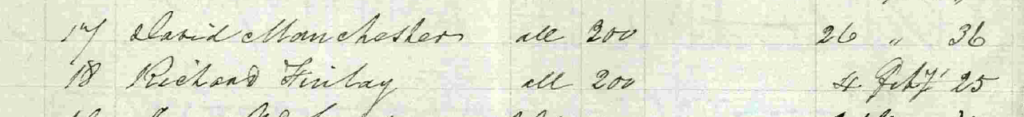
After it was first identified, this waterfall would go on to be named “Manchester Fall,” from the name of the family who owned, during the first half of the 19th century, the land on which it flows. While this name is not recognized by the Toponymy Commission of Quebec, David Manchester’s name is associated with this waterfall in different documents. A document available on the website of the Registry of the Surveyor General of Quebec compiles a list of people having obtained lands in the township of Rawdon. This document identifies David Manchester as grantee of lot 17 and Richard Finlay as grantee of lot 18, as shown in this excerpt.
David Manchester – He reportedly gave his family name to the 1st Fall
Born in November 1779 in a location that remains a mystery to this day, David Manchester had a career that showed a great deal of determination. While several of his contributions to the development of Rawdon are still unknown, it must be acknowledged that David Manchester acquired enviable expertise in mill construction and the region’s forest industry.
It is believed that David Manchester came from a family who was from the state of New York and was loyal to the British Crown and that he arrived in Lower Canada around 1806 and settled in the seigneury of Terrebonne, as noted by Daniel Parkinson in his book Up to Rawdon. In fact, Daniel devotes a chapter to David Manchester and his family. The title of this chapter, “David Manchester: Entrepreneur,” very aptly describes the career of this figure and several others having marked the history of Rawdon.
With little or no schooling, David Manchester identified himself, according to census records, family archives obtained by Daniel and additional information from notaries' archives, with multiple titles including carpenter, miller, master miller, millwright and farmer at the end of his career. His name also appears in various notarial deeds as lumber negotiator/merchant and expert in mill construction. Statements from the teachers of his children at the Forks School suggest that, while he was able to sign his name, David Manchester did not know how to read or write.
David Manchester’s name was quickly associated with the McKenzie and Oldham families. The estate of Simon McTavish had leased, in 1805, the seigneury of Terrebonne to Henry McKenzie, a seigneurial agent as of 1803. Henry McKenzie joined his brother Roderick, a former partner of McTavish, and Jacob Oldham, a lawyer who had become a merchant, in setting up McKenzie, Oldham and Co. This company managed the Île-des-moulins, a pre-industrial complex located in Terrebonne. Roderick McKenzie, first known as a fur trader, was also a militia officer, justice of the peace, politician and author, as well as seigneur of Terrebonne from 1814 to 1824, as summarized in an article from the newspaper La Revue dated June 30, 2017. A lawyer born in England, Jacob Oldham arrived in Quebec around 1791. He settled in Terrebonne, became seigneurial agent for Terrebonne and was also elected a member of the legislative assembly for Effingham (Terrebonne) in 1820. A contract signed before the notary Joseph Brunelle dated August 20, 1817, between David Manchester and Jacob Oldham indicated their will to do business together. This contract brought together leases signed by David Manchester for lands with sawmills located on the Mascouche River and by Jacob Oldham for a farm with a sawmill on the Lac Ouareau River. This last lease was signed with the Messieurs du Séminaire de Montréal, who owned the seigneury of Saint-Sulpice. Guillaume Petit specifies, with evidence from notarized deeds signed before Me. Joseph Brunelle dated September 29, 1817, that David Manchester moved to Lac Ouareau in 1817. A few years later, he sold his Terrebonne properties to a member of Roderick McKenzie's family.
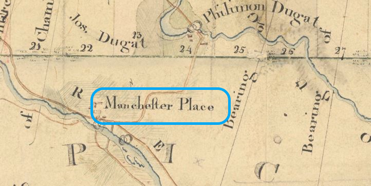
In Lacouareau, David Manchester was certainly able to impose his presence, as shown in this excerpt (below) of the map produced by the surveyor Joseph Bouchette Junior in 1821. This map identifies not only Manchester Place, the location of the mills, but also Manchester Road, the road leading from Manchester Place to the centre of the village of Rawdon and even beyond.
At Manchester Place, it is believed that David Manchester operated a sawmill and a flour mill on behalf of the Mackenzie Oldham company, although no formal document has been found confirming this. Manchester Place is located on the territory of the seigneury of Saint-Sulpice (now Saint-Liguori), a few kilometres from the Rawdon township line. A review of the notarial deeds from the office of the notary Thomas Bédard revealed that Mr. Manchester was very active during his stay at Lacouareau. Between 1818 and 1820, he acquired several pine logging operations and various plots of land. His reputation even exceeded the territory of Lacouareau. From the office of the notary Barthélémy Joliette, a report produced on March 17, 1821, at the request of the widow of the seigneur (Pierre Louis Panet) of the seigneury of Ailleboust, shows that David Manchester acted as an expert to determine the compliance with the specifications of the construction of a mill and its water supply dam. This report identified a long list of non-compliances to be corrected by the contractor.
The agreement signed on April 4, 1822, before the notary Thomas Bédard brings us back to the territory of Rawdon. David Manchester acquired the rights to the 200 acres of land of lot 18 on range 4 of the township of Rawdon. These rights belonged to Richard Finlay, an “Irish immigrant” who had obtained them on July 12, 1820, from Joseph Bouchette, the Surveyor General. Richard Finlay declared that he was unable to satisfy the conditions imposed. The agreement gave David Manchester the full power to substitute himself for Richard Finlay and meet the conditions to be satisfied to obtain the letters patent. This agreement provided for a payment of “cinquante piastres d’Espagne” (fifty Spanish dollars) by David Manchester to Richard Finlay at the time of signing the agreement and a payment of a “pareille somme de cinquante piastres d’Espagne” (same amount of fifty Spanish dollars) in June. This agreement included various clauses protecting David Manchester if he did not succeed in obtaining the letters patent/grant. David Manchester still lived in Lacouaro [sic] in the parish of Saint-Jacques at the time of signing this agreement, as specified in the text of the agreement.
In his book Up to Rawdon, Daniel Parkinson mentions that it is impossible to determine with any certainty when David Manchester moved from Lacouareau to Rawdon, as he does not appear in the 1825 census records for Rawdon, Lacouareau or Saint-Jacques. Daniel suggests that this would be after 1826. Guillaume Petit, with evidence from notarized documents, states that the move took place between February 1st and September 20, 1830. Marcel Fournier, with clarification from Daniel Parkinson, confirms that Tickets of Location were issued on July 12, 1820 to Richard Finlay, an Irish Protestant immigrant (Range 4 - Lot 18), and his sons (Richard jr.: Range 4 - Lot 17 South and Thomas: Range 4 - Lot 17 North). Although there are no documents to confirm this, it is likely that Richard Finlay's sons also assigned their rights to the lots allocated to them under agreements similar to the one signed by their father. Letters patent covering the whole of lot 17 were issued on September 26, 1836 in the name of Manchester. Richard Finlay had already obtained letters patent for lot 18 on February 4, 1825. David Manchester had to recover them under the aforementioned agreement. As David Manchester became the owner of lots 17 and 18, which would include this first waterfall, it is highly likely that the population of Rawdon came to identify this waterfall as David Manchester's waterfall, or simply "Manchester's waterfall".
A farmer on his lands in Rawdon along the falls that would bear his name, David Manchester remained active until his death around 1833, although he began to dispose of some of his lands in 1829. Members of the Manchester family kept lands in Rawdon for several more years, such that the Manchester name still appeared on the map, identified as the Holtby Map, annotated around 1845.
While we are still missing many pieces of information to know more about David Manchester’s history, we must thank Yves Forest, Daniel Parkinson and Guillaume Petit for their contributions.
Location and mapping – Manchester Fall
The GeoGratis site of the Government of Canada determines the geographic coordinates of many locations in Canada in decimal format to seven significant figures. The Toponymy Commission of Quebec indicates only five significant figures but also provides the coordinates in sexagesimal format (degrees, minutes and seconds). Rawdon’s six falls are listed. The following table presents the coordinates of Manchester Fall in decimal format from the Government of Canada site and in sexagesimal format from the Toponymy Commission’s site:
| Coordinates | Decimal | Sexagesimal |
| Latitude | 46.0336111 | 46⁰02’01’’ |
| Longitude | 73.6852778 | 73⁰41’07’’ |
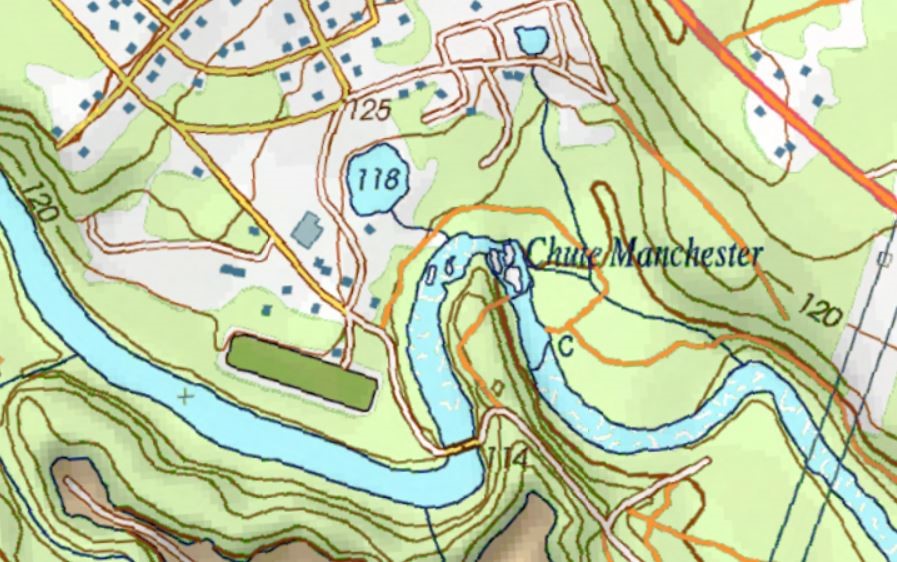
A topographic map produced by the Government of Quebec shows the location of this waterfall. A map available on the site of the Registry of the Surveyor General of Quebec must be used to locate the fall on the original cadastre of the township.

Manchester Fall in the 21st century: photographs
These photographs show the beauty of this 1st Fall or Manchester Fall.
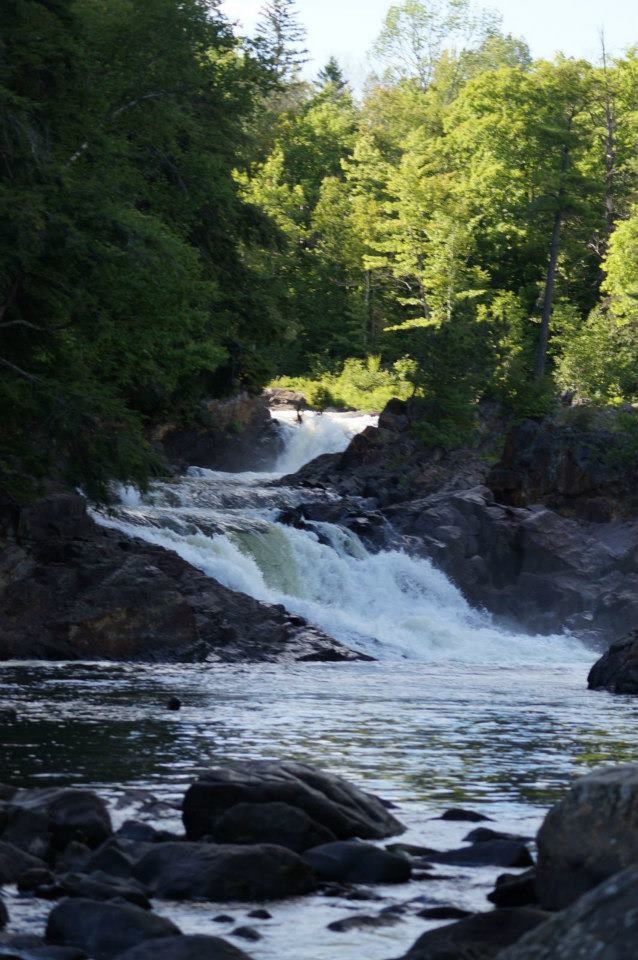
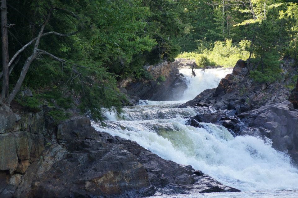
These photographs were made available to the Société d’histoire de Rawdon thanks to the collaboration of Mr. Yvan Boudreault and Mr. Pierre Leclerc.
- Plan of the Townships of Rawdon & Kildare/Joseph Bouchette Jun, Deputy Prov. Surveyor, Oct. 31st 1821
- https://www.quebec.ca/habitation-et-logement/information-fonciere/greffe-arpenteur-general – Document CA20R005_8_2
- https://numerique.banq.qc.ca/patrimoine/details/52327/4549087
- https://vgo.portailcartographique.gouv.qc.ca/mobile.aspx?gpz_point=-7409952.391302186,%206215035.784324403&echelle=8735660&epsg=3857&gpz_nomMap=-%20Carte%20topographique%2020k
- Registry of the Surveyor General of Quebec – Township of Rawdon (consulted on September 10, 2023), https://appli.foncier.gouv.qc.ca/gagq
- Up to Rawdon: Settlers at Rawdon Township, Lower Canada, C. 1820-1852: Their Origins and Continued Migration Across Canada and the United States, Volume 1 & 2 / Daniel Parkinson, 2013, 1156 pages
- Chroniques anachroniques / Guillaume Petit (https://montrealbb.ca/moulins-ouareau-1850/)